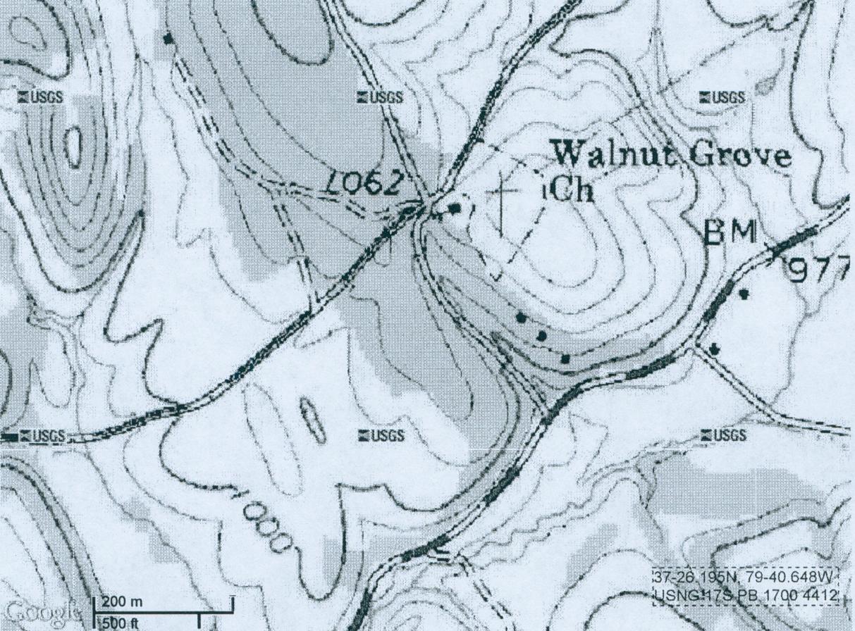
The topographic map shows two ovals: a small oval to the east (about 250 feet in
length) and a larger oval to the west (about 500 feet in length). The small oval is a depression that corresponds to the brown
area on the Google Earth map. If one looks closely, one can barely make out tiny hash marks on the inside of the small oval.
These are used on topographic maps as a symbol to indicate a depression. The larger oval is a hill or actually higher ground,
which is part of the rim of the caldera. Unfortunately, the crater is only 20 feet deep, more or less, and with contour lines
20 feet apart, it barely shows up.
Beale's plan was to put the treasure in a cave, which he says "all of us had visited."
But it was too frequently visited by neighboring farmers, and so they soon "selected a better place," which was
agreeable to everyone. It is interesting that Beale used the word "selected" rather than say, the word "found."
In any case, Beale made no mention of a map, yet there is no indication that the 19 men left behind in 1819 had any difficulty
in ascertaining the location of the hidden treasure. How was that possible? Even today one can get lost in this area without
a map. But, Beale's men must have hunted in the area. Thus, it could mean and probably did mean that Beale and his men were
already familiar with this very unique landmark, just as they were with the mentioned cave. Hence, they had no need for a
map, and no need to spend valuable time searching for a suitable secondary burial site. I feel that this is a critical point.
If there wasn't any map, then the treasure is more likely to be in the caldera, for the same reason that at first Beale intended
to deposit the treasure in the mentioned cave, not somewhere adjacent to it.
Beale told how "the vessels rest on solid stone." This is
the only rock around in any direction. He mentioned "an excavation or vault." It sounds like he dug or excavated
into the higher upper bank of the caldera, set the iron pots with lids on solid stone/rock, then covered them up.
The long narrow strip of rock would lead straight to the vault. Remember he said "No difficulty will be had in finding
it." Maybe this is what he meant. I hope someone might give it a chance, it should be a lot easier than trying to break
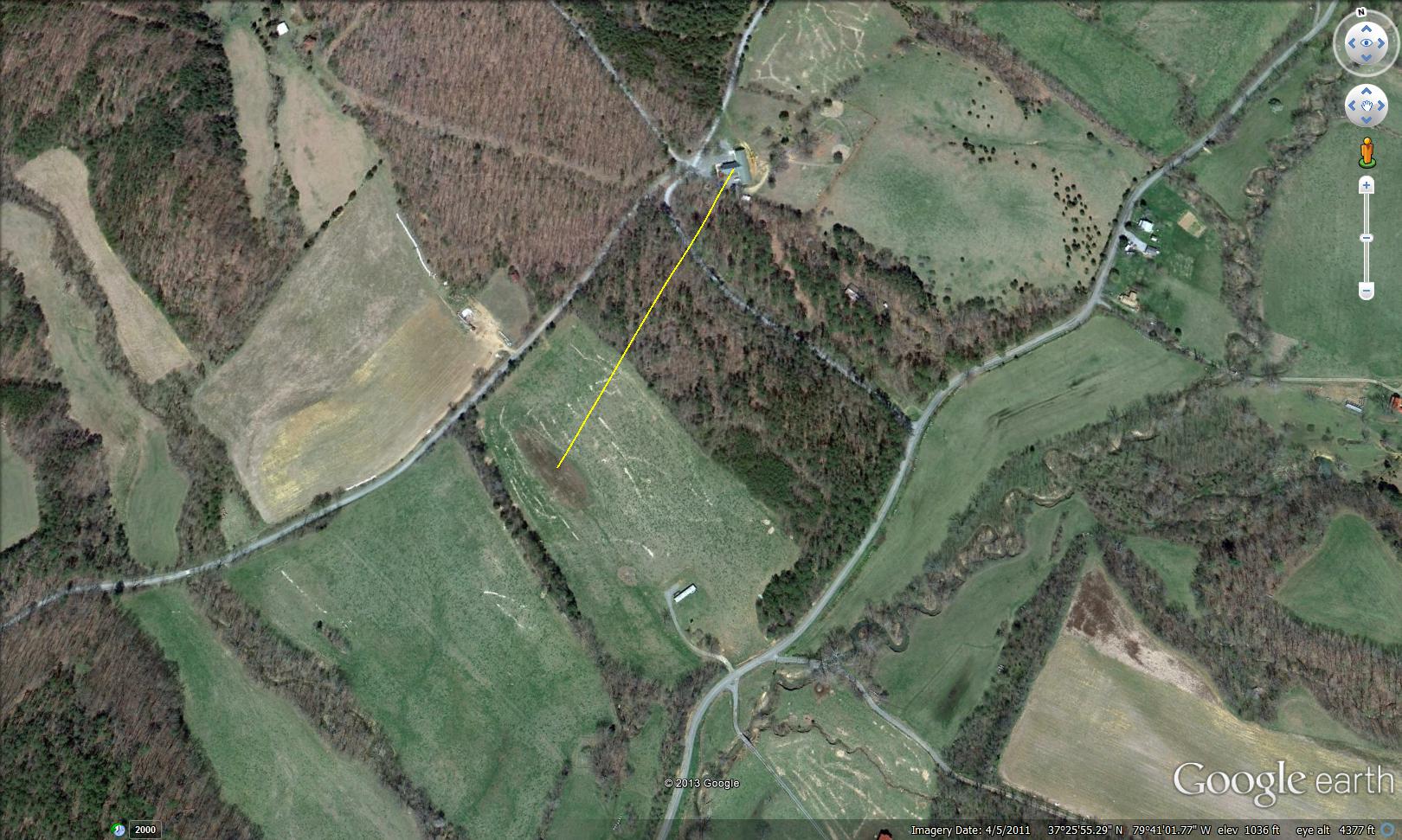
the code, and might lead to the same place. Current computer maps now show a roofing company at this site. Please respect
private property, as you know Beale would have done.
SIGNED: Sam Peppiatt.
Mr. Peppiatt first read about the Beale treasure story in an early article published in True
Treasure magazine. Becoming interested, he traced Beale to the Wet Mountain Valley close to the historical mining town
of Silver Cliff, in Custer County, south-central Colorado. The ore, known as horn silver, is 60% to 70% silver and only requires
roasting to produce metallic silver. Gold from Telluride ore is produced the same way.
Beale stated that the mine was 250 or 300 miles
from Santa Fe, NM. He might have meant 250 miles by horse back or 300 miles by wagon. As it happens, Silver Cliff, Colorado
is almost exactly 300 miles from Santa Fe, on present day highways! The area was known by the Mexicans as the "Incredible
Lue" with pastures of gold and silver. Peppiatt researched the treasure story using topographical maps. He reasoned that
Beale would very likely choose some unique natural feature in the Goose Creek Valley as his burial site, assuring that it
could be easily located. He took a chance and ordered the Montvale, 7 1/2 min. quadrangle. And there it was! The caldera was
clearly shown on the map, and just the right 4-mile distance from Montvale. And if you find it, he wants one of those iron
pots with the lid!
His brother Alfred visited the location in 1987. He parked his car at the upper end on Pike Road, walked down and
checked out the rock. At that time it was exposed on the surface, 10 to 12 feet wide and roughly 300 feet in length, with
brush growing in some places and possibly a small tree here or there. Basalt can vary in color from reddish brown, brown,
dark brown, or black. The rock was visually inspected, although it was never assayed or tested.